|
|||||||||
|
ARTICLESBeijing, The City Made ManifestKelly LaytonIn 1911, the year in which his autofictional novel, René Leys, is set, the French writer and Sino-obsessive Victor Segalen considered the springtime prospect of Beijing from the top of its Bell Tower in the north of the Tartar City (or 'Nei Cheng' 内城 in Chinese, once the exclusive preserve of the Manchu Qing rulers and their immediate coalition allies). It was the year before the abdication of the last ruling Manchu emperor, Xuantong (Puyi, 1908-1911), an event that marked the end of Segalen's beloved Qing dynasty, and eight years before the author's bloodied corpse would be found in a forest in Brittany. Perhaps frustrated by his failure to uncover the secrets of imperial Beijing by penetrating its Forbidden City from ground level (a frustration reflected in his writings), it was from this vantage near the northern-most tip of the city's cardinal north-south axis that he could come to dominate the city in another way, by considering its grand fabrication with a 'founder's eye', from on high: I can think of no better way of passing the time between lunch and the evening before me than by indulging in a lengthy contemplation of the city itself from its highest point.[...] Looking due south over the white crenellations of the terrace I shall see the bulky "Ku Leu" or Drum Tower, the Hill of Contemplation, the distant, sealed-off Palace, the walls of the Tartar City forming a categorical, angular barrier...and beyond, farther to the south, the misshapen rectangle of the Chinese city [...]. With a founder's eye I shall trace the vast quadrilateral of which the Chinese city is but the southern suburb, the entire monumental concept dreamed by the Great Emperor [...]. Within its fictive or actual confines I know that, from the top of the Bell Tower, I shall see the Northern Capital spread out before me over its plain like a mosaic in willow-green, yellow (the palace roofs), and gray (the private houses).[1] For Segalen, then, the Beijing that appeared to him as he looked down from the Bell Tower was a mosaic of colours and shapes that bespoke spatial delineations and social demarcations, a patterned picture that lent itself to his contemplative gaze. It was also from here that the 'monumental concept' of the city, belied by everyday life on its streets, appeared before his eyes. By removing himself from the prosaic concerns of the mundane world below, and elevating himself to the city's highest point, Segalen accessed constellations of meaning unavailable at ground level, ones that would have suited his particular quiet, and imaginary, conquest of the capital. From the Bell Tower he could also indulge in a certain forgetfulness that Michel de Certeau has noted in his contemplation of cities.[2] For Segalen, to view the city from above provided a leisurely way of passing the time during his days in Beijing. Thinking and seeing from this lofty position proved the perfect place to contemplate his object of obsession with no hindrance from what for him remained an obstreperous city that would never yield its secrets to him. 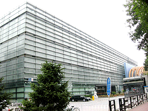 Fig.1 The Beijing City Planning Exhibition Hall lies to the south-east of Tiananmen Square next to the old train station. [Kelly Layton] Over the course of the 20th century, the entire 'Great Within' (Da Nei 大内), the Forbidden City that Segalen so longed to possess, would be slowly yet inexorably eviscerated. In this grim process those remaining contents that survived the banditry, neglect and sabotage were eventually museum-ified as a part of a desacralised tourist Mecca.[3] The surrounding city would also be affected, with the old crenellated walls, "a categorical, angular barrier" as Segalen calls them, eventually supplanted by multilane ring roads, just as the city gates were replaced by traffic junctions, with their names serving as spectral reminders of their irrevocable passing. Yet despite the tumultuous changes that would take place in Beijing/Beiping over the years of the Republic of China (1912-1949) the picture of the city from on high evoked by Segalen would remain substantially unchanged. Even the revolutionary and economic reconstruction of the city from 1949 until the present day remain haunted in powerful and complex ways by the perdurance of the former imperial design. Further on in his account Segalen takes on an even loftier purview, and describes a map of the city. What began with his contemplation of Beijing from the Bell Tower here reaches its apogee, with the physical city finally removed, leaving the monumental structures and design of the place reduced to lines on an abstract plane. According to Segalen, this latter meditation was based on his consideration of a map drawn up by the Allied occupation force in 1900 as they moved to relieve the siege of the diplomatic quarter following the Boxer Rebellion. It was a document that itself forms part of a lineage of conquest, one that brings to mind Walter Benjamin's oft-quoted statement that there "is no document of civilization which is not at the same time a document of barbarism".[4] Returning, however, to Segalen, his fantastical, libidinous possession of the city found completion in an overarching vision provided by a map of the celestial capital.[5] And here, before my eyes, between my two hands spread out at less than a man's full span, I see, unfurl, spread out, hold, and possess, at small financial cost, the plane representation of the city as a whole, this capital and all it contains—Pei-king.[6] Segalen describes the two segments that make up any map of what is now called the old city of Beijing, the Tartar City and the Chinese City ('Wai Cheng', 外城), as "a Square set on top of a Rectangle".[7] He situated his own property as a "discreet conqueror" in the "bottom right-hand corner" of the Tartar City, where he himself possessed "a tiny square".[8] The Tartar City enclosed the Imperial City, around which is a further, misshapen wall. And lastly, the form of the Forbidden City itself—the object of Segalen's fascination and desire—scaled down and diminished: a final, third purple rectangle.[9] Maps bring disparate elements together. They create continuities usually through the rendering of three dimensions into two, by shrinking huge geographies into something that may fit into one's pocket, and through providing an unchanging image of a place removed from the relentless vicissitudes of time. Maps also displace continuity with artificial differences through the use of lines, demarcations and borders. They augment and diminish perspective in many ways, through the displacement of time, the loss of dimension, erasure and effacement. They render the whole while perpetuating difference. In this way, maps can be seen as both concrete representations of space as well as abstract images that borrow from, and share their origins with, fields such as art, aesthetics, rhetoric and politics. All simple lines and shapes, with the real physical barrier of the city-proper finally surmounted and removed, the map proved to be the perfect, simplified plane above which Segalen's imagination could float and fantasise. Officialdom strives to create a magical reality. Michael Taussig, Shamanism, Colonialism, and the Wild Man[10] 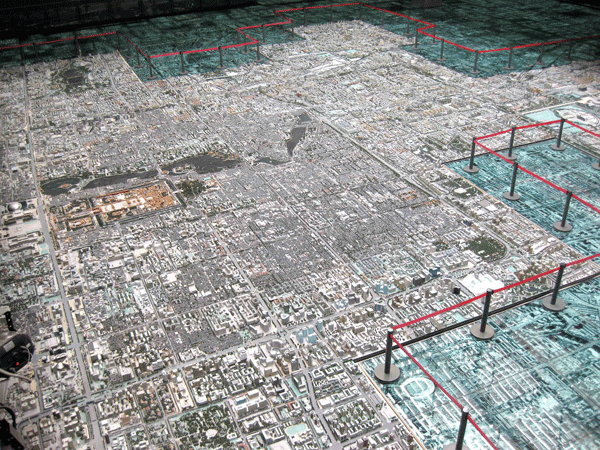 Fig.2 The model of Beijing in the Beijing City Planning Exhibition Hall viewed from the floor above, with the Forbidden City an orange brown shape to the left. [Kelly Layton] Located on Qianmen East Avenue, on the east side of the old Beijing railway station, not far of the Front Gate of the Tartar City and Tiananmen Square, lies the Beijing City Planning Exhibition Hall (Beijing shi guihua zhanlan guan 北京市规划展览馆). Opened in September 2004, and encased in a facade of black steel and glass, it contains 8000 square-metres of exhibits across four floors. By means of an unusual mixture of traditional display techniques, interactive exhibits as well as highly sophisticated film and digital media displays (which range from the interesting to the near-psychedelic), the hall presents a grand yet uneasy vision of Beijing, inviting visitors to experience and participate in a story of the origins, development and future of the city.(Fig.1) 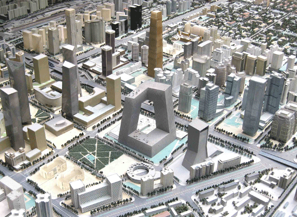 Fig.3 The model CCTV Tower. [Kelly Layton] While much of the hall contains exhibits detailing and the specific planning and development of the city's 18 counties and districts, including a 3D movie theatre, the centerpiece of the displays is located on the third floor. It is a gigantic 302 square-metre 1:750 plastic and wooden scale model of Beijing itself. Some 150 workers constructed it in the space of a year at the cost of over four million yuan. The three-dimensional model is also encompassed by a set of identically scaled glass-covered satellite photographs of Beijing's conurbation illuminated from below, upon which viewers may walk, adding to the spectacular effect of the splayed urban vision. From these photographs the grandly rendered texture of the inner districts of the city, the subject of the model, emerges in striking detail. Balconies on the floor above afford visitors an aerial view of the city, amplifying the schizophrenic effect of this simulacrum: the viewer's experience fluctuates between the knowledge of the artifice of the model and the uncanny sense of reality that it invokes.(Fig.2) The model is a version of Beijing in miniature, allowing the visitor's gaze take in the vista of the entire city with a single sweep, or to move 'peripatetically', lingering for a time on specific features. It does not just render certain aspects of the city's planning visible, but also provokes a certain kind of seeing, in which reality and vision combine. 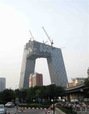 Fig.4 The CCTV tower under construction in downtown Beijing, in June 2008. [Kelly Layton] 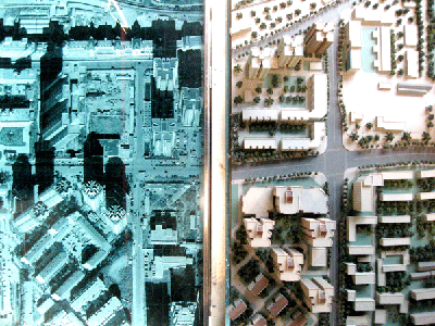 Fig.5 The present (left) makes way for the future (right). [Kelly Layton] By seeing the city from this overarching position the visitor can enjoy the kind of imaginary possession of the city that proved so intoxicating for Segalen. However, the vision proffered is not one of a conqueror surveying a pacified, subjugated territory. For it is also from this height that the embrace of the future city itself is possible, tacitly educating, and operating, in the words of the philosopher Jean-Luc Nancy, as "a sight that operates like a saying".[13] The model, in other words, is a social and cultural object that plays its own part in the dissemination of power and the construction of people's relationships with the city around them. In the Hall, possession is thus a two-way street.  Fig.6 The promise of things to come; scaffolding surrounding a construction site near Llama Temple, in June 2008. [Kelly Layton] Subways, overpasses and skyscrapers, many of them already present in the cityscape as cement and steel slabs or dilapidated fences encompassing gargantuan holes in the earth in which countless labourers toil in the city outside, occupy the model, complete and perfect, providing residents with an unimpeded version of the future. It is a promise that presumably makes it easier to live with the dust of the present. There is, for example, the completed 'new downtown' or CBD around the World Trade Centre in Jianguo Menwai, east Beijing, and Zhongguan Cun Technology Park, in the northwest, whole and unadorned by the usual cranes, scaffolding and milling workers. The new Rem Koolhaas-designed China Central Television tower, currently under construction in Beijing's east, also stands finished.(Figs. 3 & 4) The recently opened Olympics 'Bird's Nest' stadium and 'Water Cube' swimming hall, on the North Fourth Ring Road, have stood complete here in scaled-down form since the model first appeared nearly four years ago. They form the geographical apex of the newly extended south-north axis upon which the original Ming-dynasty city was aligned, one that runs from the recently reconstructed Yongding Gate in the south, through the throne halls of the Forbidden City, to the Bell Tower to the north, and into a future that becomes manifest in August 2008.  Fig.7 A 'Beijing 2008' clock counting down to the opening ceremony of the summer Olympics, outside the 'still-under-construction' National Museum of China. The 'windows' at the front are actually a facade of plastic sheets. June 2008. [Kelly Layton] 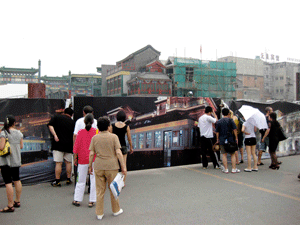 Fig.8 People lining up to peek through the scaffolding at the Qianmen construction site, June 2008. The site was being developed by SOHO. [Kelly Layton] The way time is impressed into the model and tacitly emphasised is instructive. In this 'model city' the two-dimensional satellite photographs underneath the glass floor depict the present, in dim hues of green-grey. This allows for the designers of the three-dimensional model, which depicts a not-yet-present, or a present-to-be version of the city, to borrow from a kind of privileged access that photography has to (at least imagined) truth by engineering a physical contiguity with them. Thus, the real gives way to the make (or want-to) believe at the same time as reinforcing it. In this process the future is also elevated, both metaphorically and literally, above the muted present.(Fig.5) It is a present (or rather the present of the past few years) that, in some sense, has thus already been relegated to the infamous 'dustbin of history'. The future city may be figured in terms of wei lai 未来 (the Chinese word for 'the future' that means literally 'that which has yet to come'), yet here it is literally not far from the truth, and the photographs depict a present city that, as soon as it is imagined beside the model, appears antiquated. In looking at the ever-changing skyline of 'actually lived Beijing' and contending with the chaos of construction, the city's residents are always urged to see the present condition as a transition to that almost-present future, a future that sweeps all up into the structure of promise.(Fig.6) While the Master Plan of Beijing sets an agenda for Beijing's long-term rehabilitation and transformation, it is nonetheless doubtless that the 'moment' of the 2008 summer Olympics is also the moment that, symbolically, the future (as it has been pre-emptorily narrated over the past few years) will have arrived. Reminders of this imminent arrival are ubiquitous in Beijing, and the model forms but one part of this broader civic imaginary present in the immense signage of the city. The most conspicuous of these signs are the monumental clocks located at various points in the city, the most famous being on the eastern flank of Tiananmen Square. They offer a count down to the beginning of the Olympics on 8 August 2008.(Fig.7) However, the new malls and public spaces, recreated antiquarian heritage sites, museums, commercial centres, construction sites, as well as public works (such as the expanding encirclement of ring roads and the thrust of rapid transit systems) are all saturated with signs and slogans that attest to and ramify this new civic imaginary, paired with the civilising discourse of the Harmonious Society (hexie shehui 和谐社会). By way of this signage, residents have slowly learnt to be at home within what was once just the image of a possible future, and urban planning models and architectural plans have been provided with the timbre of inevitability.(Figs 8 & 9)  Fig.9 Posing by the future at Qianmen, in June 2008. [Kelly Layton] A visit to the Beijing City Urban Planning Exhibition Hall allows one to partake in a view of the future city from on high, revealing its monumental grammar. Perhaps more importantly, however, this model of future-Beijing sheds light on the broader civic imaginary that gives sense and direction to the lives of those in the present. The notion of the city-to-come, of Beijing as a modernised megalopolis with a glorified past, is also implicit in all negotiations to decide what is worthy of being preserved, or reconstituted (and how), and what may be justifiably destroyed. Just as 'new' Beijing has had to contend with the uncanny spectres of its past, so too has the reconstituted past of Beijing had to contend with the invisible city of its future. Kelly Layton is a graduate scholar at The ANU, presently resident in Beijing. Notes:[1] Victor Seglaen, René Leys, New York: New York Review Books, pp.52-3. [2] Michel de Certeau, The Practice of Everyday Life, Berkeley: University of California Press, 1984, p.93. [3] Geremie R. Barmé, The Forbidden City, Cambridge, Ma.: Harvard University Press, 2008. [4] Walter Benjamin, Illuminations, London: Fontana, 1992, p. 248. [5] It is a form of symbolic possession not unrecognised in Chinese history itself. Indeed, according to Pierre Ryckmans, "there is an ambiguity in the Chinese character tu, which means both map and image. Originally, to possess the map-image of a territory was to have control over that territory. In international relations in pre-imperial China, when a state yielded territory to another state, the transaction was effected by surrendering the map-image of that territory." From Pierre Ryckmans, The Chinese Attitude Towards the Past, reprinted in this issue of China Heritage Quarterly under Articles. [6] Segalen, op. cit., p.87. [7] Loc. cit. [8] Ibid., p.88. [9] Loc. cit. [10] Michael Taussig, Shamanism, Colonialism, and the Wild Man: A Study in Terror and Healing, Chicago: University of Chicago Press, 1986, p.4. [11] The contents of the 2004-2020 Master Plan of Beijing City can be assessed online through the Beijing Municipal Commission of Urban Planning website at: http://www.bjghw.gov.cn/ztgh/. [12] Michael Dutton, Hsiu-ju Stacy Lo and Dong Dong Wu, Beijing Time, Cambridge, Ma.: Harvard University Press, 2008, p.38. [13] Jean-Luc Nancy, The Ground of the Image, New York: Fordham University Press, 2005, p.80. |