|
FEATURES
Taming the Floodwaters | China Heritage Quarterly
TAMING THE FLOODWATERS:
THE HIGH HERITAGE PRICE OF MASSIVE HYDRAULIC PROJECTS
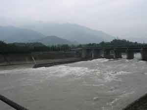
Fig. 1 Overview of the site of the ancient Dujiangyan water control project, Sichuan province [BGD]
China's self-reliance in engineering matters, especially from the 1960s onwards, often resulted in aversion at the highest decision-making levels to criticism from environmentalists and conservationists, and this atmosphere prevailed through the 1990s. Now that the country has embarked on a massive project to divert water from the Yangtze River valley to the arid north it is determined to tackle all potential heritage conservation issues at the outset. The South-to-North Water Diversion project was first mooted in the 1950s, and the construction of Danjiangkou reservoir in Hubei province was the first step in realizing the plan. This dam resulted in the destruction of many historical sites, little publicised at the time. In the 1980s and 1990s intense ecological and conservation debates surrounded construction of the Three Gorges Dam, and in the course of these many lessons were learned, some of them too late. In the late 1990s the world heritage site at Dujiangyan (Fig. 1) was also threatened by a major hydraulic engineering project. Again planners and engineers were pitted against conservationists with heritage concerns. Now that the bulldozers have begun operating along the course of the planned South-to-North Water Diversion, heritage conservation officials under the State Administration of Cultural Heritage are keen to repeat none of the mistakes associated with Danjiangkou reservoir, the Three Gorges catchment area and the Dujiangyan site, and have drawn up a massive plan to protect these sites. Here we outline these efforts, and contrast the present situation with the badly handled Dujiangyan case of three years previously.
SOUTH-TO-NORTH WATER DIVERSION
It was during an inspection tour of the Yellow River in October 1952 that Mao Zedong remarked, "There's a lot of water in the south, but not much in the north. If we could borrow some, then things'd be OK". The ripple effect of this seemingly whimsical comment gained force when Mao returned to the theme of diverting water from the Yangtze and Hanjiang rivers northwards at a Central Committee conference in Chengdu in March 1958, and so in August 1958 the Enlarged Meeting of the Politburo at Beidaihe passed its Directive on Hydraulic Work (Guanyu shuili gongzuo de zhishi), in which the term "south-to-north water diversion" (nanshuibeidiao) was added to the political vocabulary of the Chinese language. In the following month, at the height of the Great Leap Forward, work began on the Danjiangkou Reservoir in Hubei province and the first step in the envisioned water diversion scheme was taken.
It was not until 1967 that the dam was completed and began to fill. By then the south-to-north water diversion had been shelved quietly, but the Danjiangkou Reservoir took its place as a hydroelectric source. In the 1990s the water shortage in China's north had become increasingly acute, and so in April 1991 the 4th Session of the 7th National People's Congress included the South-to-North Water Diversion project in the 8th Five-Year Plan and the Ten-Year Plan. In December 2002, an idea broached almost half a century earlier came to fruition and the State Council initiated the Plan for South-to-North Water Diversion Project (Nanshui Beidiao Gongcheng Zongti Guihua).
The South-North Water Diversion project estimated to cost RMB 100 billion (approximately USD 12 billion) will channel water from the Yangtze River and its tributaries to the Yellow, Huai and Hai rivers. The project will have three water transfer routes – east, west and middle.
The middle or main route project (MRP) will divert water from Danjiangkou on the Haijiang river, a tributary of the Yangtze, to Beijing via canals built through the Funiu and Taihang mountains. The flow will be gravity fed and the total length of this planned canal is 1,274 km. The first step in the construction of the MRP is raising the crest elevation of Danjiangkou Reservoir from 162 m to 170 m. The main channel will cross the Yellow River through tunnels at Gubaizui and this will be one of the most complex engineering projects of the MRP.
The eastern route project (ERP) will link Shandong with the Yangtze River when completed in 2008. The project will supply water for the plains surrounding the Yellow, Huai and Hai rivers by raising water through the Grand Canal, which runs from Beijing to Hangzhou. The eastern channel will be 1,150 km in length from the Yangtze River to Tianjin and 90% of this diversion channel will make use of existing rivers and water channels, and this project will include 30 pumping stations.
The western route project (WRP) is still in the planning stages, and it is not anticipated that it will be finished until 2050. It will cut through mountain ranges adjoining the Qinghai-Tibetan Plateau to link the Yangtze with the headwaters of the Yellow River.
Between May 1958 and December 1959, before work began on the Danjiangkou Reservoir, China's Ministry of Culture, the Institute of Archaeology (then under the Chinese Academy of Sciences), and the Yangtze Drainage Area Planning Office jointly established the Yangtze Drainage Area Planning Office Archaeology Team. The team identified more than 100 archaeological sites in the catchment area, but was only able to excavate 23 sites and 15 graves and to move 11 above-ground heritage structures to safe ground. Excavations at the Qinglongquan, Dasi and Xiawanggang sites enabled archaeologists to sketch in the broad outline of neolithic development in this area but little else.
By 1974 Danjiangkou Reservoir had filled, forming Asia's largest man-made lake, and the surrounding area was a depopulated wasteland with little remaining infrastructure. Many sites lay below the surface of the lake, including the Taoist temple known as Jingle Palace, of which only stone carvings remain today. The temple was the most important of the eight Taoist temples of Wudangshan. The Wudangshan Taoist temple complex was listed by UNESCO as a natural and cultural world heritage site in 1994, and is described on the UNESCO website as representing "the highest standards of Chinese art and architecture over nearly 1,000 years". Wudangshan is an integrated site of mountains and temples, described as the home of taijiquan ("shadow boxing"). Tomb robbers operated with impunity in the area and had a rich trawl, and by the 1990s relics plundering reached an acute level. The State Cultural Relics Bureau organised several rescue excavations of known plundered tombs. Between 1994 and 1997 the reservoir authorities organised a large "cultural relics survey" of the entire area and 287 cultural relics sites were identified. Sixty of these were palaeo-zoological and palaeo-anthropological sites, 189 were underground sites and 38 were above-ground sites.
In June 2003 the State Cultural Relics Bureau and the Ministry of Water Conservancy came to an agreement, after protracted discussions, on heritage work related to the MRP, work described in the agreement as "an important and integral part of the project". In September that year an office was set up to coordinate MRP heritage work and in November the State Cultural Relics Bureau began drafting cultural heritage conservation plans for the eastern and western diversion channels.
The main and eastern channels will pass through seven provinces and by December 2004, heritage plans – or rather targeted sites - had been drawn up for all seven, with the exception of Tianjin municipality, for which the engineering plan was being revamped. The State Bureau of Cultural Relics has been quick to point out that it was not included in the initial negotiations that led to the promulgation of the project by the State Council in 2002, and that it was only included in project planning discussions after March 2004. Because the final plan for the project, including the input of the State Bureau of Cultural Relics, will be released at the end of the first quarter of 2005, the bureau has had to move quickly. For this reason they have outlined the sites they will work to preserve, further excavate or re-locate, but the tasks are gargantuan.[1]
The current low water levels in the Danjiangkou Reservoir afford archaeologists the opportunity to excavate sites identified in the 1958-1959 survey, but neglected at that time. Raising the height of the reservoir also necessitates giving priority to the area around the reservoir, excavating identified sites and moving endangered heritage structures to safe ground. The pace of archaeological and heritage work will be intense as 210 locations have been earmarked for salvage. Another of the Wudangshan Taoist temples will also probably be inundated when the level of the dam is raised. This is the Yuzhen Palace, a 600-year old building that features the finest of late Yuan and early Ming architecture. Proposals to save the large temple complex include elevating it in Abu Simbel style, moving it to another location or building dykes around it, but all these proposals are problematic and a solution has not been found. Others believe Yuzhen Palace should be left to the floodwaters as the main hall was burned to the ground in January 2003 and only one wall of the building is now left standing.
The South-to-North Water Diversion Project Overall Plan envisages that work on the eastern route will be completed in five years, and that on the main route in eight years. For this reason, the Cultural Relics Bureau believes work should focus on the rescue excavation and re-location of sites in the Danjiangkou Reservoir catchment area and along the eastern route.
Some of the "cultural relics" sites to be inundated by the MRP are potentially rich archaeological sites where excavation has progressed intermittently over a long period. Notable among these is the site where Yunxian Man (dated to c. 800,000 BP), China's best-known example of Homo erectus after Peking Man, was discovered. Notable recent and related palaeo-anthropological discoveries in Yunxian county were made at the Xuetangliangzi locus in Mituosicun village, where in 1989-1990 two Homo erectus fossils, also dated to 900,000-800,000 BP were discovered. Yunxian county will undoubtedly be the venue of many rushed palaeolithic excavations in the near future.
Other sites in Hubei are possibly exhausted, but archaeologists will focus their attention on them. These include:
- Beitaishanmiao graveyard is a composite cemetery site on a peninsula on the southern side of Danjiangkou lake where graves of the Eastern Zhou, Han, Jin, Song and Ming dynasties have been unearthed. The 1998-1999 excavation yielded 41 mid-late phase Warring States graves of the Chu state and large chariot and horse sacrificial pits. Many valuable Chu bronzes and two chariots were unearthed. A 2004 survey of the peninsula revealed that graves were scattered across it and so excavation here has been prioritised.
- Excavations at the Xiongjiazhuang site (located in Xiongjiazhang village in Danjiangkou) in 2004 unearthed more than 200 burial items. The site is important for the study of early Chu culture in the period extending from the Erlitou culture period to the Spring and Autumn period.
- Located in Chengguanzhen township in Yunxian county, the Li Tai clan cemetery discovered in 1958 and subsequently excavated in 1973, 1975 and 1985 has revealed valuable Tang dynasty material. This graveyard is interesting because it is the only Tang royal graveyard outside a Tang dynasty metropolitan centre.
Apart from Yuzhen Palace, another temple that is part of the Wudangshan Taoist complex is also threatened by the MRP's future floodwaters. Although little remains at the Yuxu palace, the remains of two large pavilions that once housed stelae erected on turtle's backs remain. The fate of this site also remains undecided.
The State Administration of Cultural Heritage has compiled a large list of sites throughout the regions traversed by the MRP and ERP, and it is only possible to highlight the major sites. Proceeding northwards along the MRP in neighbouring Henan province, for example, archaeological sites facing inundation include the Xiawanggang neolithic site, the Heshangling cemetery with early and late Spring and Autumn Chu state graves that yielded valuable ritual bronzes including bell sets, the Xiasi Chu cemetery which yielded some of the most technically complex cire-perdue bronzes ever unearthed (now in the Henan Museum), and the Xujialing Eastern Zhou cemetery site with its Chu graves. Hebei province will see extensive flood damage in Cixian county – a potential source of rich material for the history of Chinese ceramic technology, and Beijing will see damage to some sites in Fangshan county.
Along the ERP that runs through Jiangsu, Shandong and Tianjin, the major damage will be the loss of little studied locks, wharves, embankments and other structures that line what was once the Grand Canal. Like the Great Wall, the Grand Canal is a major cultural heritage item that has eluded listing largely because of its immensity and evidential decline. Archaeological institutes and teaching departments throughout China, as well as local authorities, eagerly await the fully detailed plan of attack being drawn up by the State Bureau of Cultural Heritage. The inclusion of the bureau at the basic planning stage of the project represents a marked departure from the planning of the Three Gorges Project, in the early stages of which heritage conservationists were not consulted. This point is spelled out clearly by Wu Hongtang, deputy head of the Hubei Provincial Bureau of Cultural Heritage, in an prefatory article in the Winter 2004 issue of Zhongguo Wenhua Yichan (China Cultural Heritage).
APPEASING THE RIVER GODS:
THE DUJIANGYAN CASE
The turning point in the confrontation between engineers and cultural heritage was signalled to the world by China Daily's 20-21 December 2003 issue that featured a special highlighting the many controversies over recent decades surrounding China's drive to construct massive hydroelectric projects, often in the face of fierce opposition of environmentalists, such as Zhang Guodou, one of China's leading hydraulic engineers. For more than a decade open discussion of the environmental and heritage consequences of these massive engineering projects had been stymied, and the details of meetings at which opponents have aired their views views were construed as "classified information". All this seems to be finally changing, largely as a result of the revelation in the press of government attempts to put a blanket ban on information concerning the Zipingpu Dam, which threatened China's oldest hydraulic project, the 2,250-year-old Dujiangyan weirs.
DUJIANGYAN BACKGROUND
The Chengdu Plain in south-western Sichuan province is one of China's most fertile regions. This is due in no small measure to long-term, ongoing management of the rapidly flowing waters of the Min River (Minjiang) - the largest and longest of the headwaters of the Yangtze River (Changjiang) - facilitated by the ancient Dujiangyan weirs and their adjunct flood mitigation and irrigation facilities.
The Dujiangyan weirs, located about 50 km from the sprawling metropolis of Chengdu with its rapidly growing population of more than 10 million, are visible testimony to the technological expertise of ancient Chinese hydrologists in balancing the need for seasonal flood control with the demand for a guaranteed water supply to sustain irrigated farming during the dry months.
At variance with conventions of water management that rely on sluices and dams to block water flow, the Dujiangyan weirs are constructed from batteries of flexible bamboo cages containing rocks sited at a bend in the Min River where the natural escarpment aids in control of the quantity and direction of water flow. The weirs divide the river into two channels - the outer channel caters to flood relief, the inner to irrigation. Since the time of their construction, the weirs and channels have required careful ongoing maintenance and dredging.
STRATEGIC ORIGINS
Scant details in two Han dynasty histories – Shi ji (Historical Records) and Han shu (History of the Han Dynasty) – indicate that the construction of the Dujiangyan weirs was supervised by Li Bing, a governor of Shu Prefecture in the 3rd century BCE. By the close of the Han dynasty a number of myths had grown up around the shadowy historical figure of Li Bing, and he had been conflated with various myths including that of the River God [2] and Great Yu. (Fig. 2)
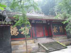
Fig. 2 Temple of Da Yu, legendary king who "quelled the floodwaters", Dujiangyan, Sichuan province [BGD]
The fullest, but possibly most partisan, account of Li Bing's hydraulic and other engineering enterprises during his long term as governor of Shu is contained in Chang Jue's Huayang-guo zhi (Annals of the Huayang Kingdom),[3], compiled in the Jin dynasty. Using that as a primary source, it would seem that Li Bing was a native of Qin appointed by King Xiao of Qin as governor of Shu Prefecture in 272 BCE. Throughout its ascendancy, Qin sought to subjugate the south-eastern kingdom of Chu, and so needed to transform the south-western Prefecture of Shu which it had conquered into a strategic base providing logistical support in a long-planned, two-pronged military campaign, success in which would elevate Qin to supremacy over the entire Central Plain.
Li Bing was commissioned to conduct an extensive hydraulic survey to regulate the unpredictable course of the swiftly flowing spring-thaw waters of the Min River that regularly flooded areas and settlements on the plains around Chengdu, and simultaneously ensure that the Min River had a fairway flow through Chengdu, facilitating navigation by military vessels that could service Qin's logistical supply lines.
By 270 BCE he had drawn up plans to mitigate the Min River's floodwaters for year-round irrigation on the Chengdu Plain and navigability to Chengdu. The original plan called for the construction of weirs or levees to harness the Min River at Dujiangyan, where the hills meet the Chengdu Plain, and of a diversion channel to irrigate the plain that would cut straight through the natural barrier posed by Mount Jian. Prior to the invention of gunpowder, manual labourers using only drill rods and stone hammers would have taken 30 years to cut through the mountain. Qin military planners required more immediate results, so Li Bing proposed using the expeditious and simple technology of using controlled blazes to scorch the rocks and then dousing them with cold water. The seemingly limitless forest resources of the region at that time – evidence of which is provided by the Shu kingdom period tree trunk coffins recently unearthed in downtown Chengdu – made such an option possible. King Zhao of Qin allocated 100,000 taels of silver for the project.
In 268 BCE, Li Bing is said to have personally led ten of thousands of workers in the initial stage of construction on the Min River banks. The workers made bamboo cages and threw cages of rocks into the middle of the river. (Figs. 3 and 4) It took them four years to complete a water-diversion levee resembling a fish's mouth. When the water reaches Yuzui, the 'fish's mouth,' it is naturally diverted into the inner and outer flows. The inner flow is the diversion channel that leads to Chengdu. It took a further eight years to cut through the mountain, and the 20 m wide culvert allows the water to flow into the Chengdu Plain. The key part of the project was the diversion gate called Baopingkou that resembles the neck of a bottle, and through this passage, the waters of the Min River could irrigate the Chengdu Plain in perpetuo. In 256 BCE, after 14 years of arduous labour, the Dujiangyan project was completed. That, at least is one received historical account, but it is undeniable that for more than two millennia this irrigation project has been in use on the Chengdu Plain.
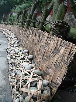
Fig. 3 Reconstruction of wicker baskets and stones traditionally used to divert river flow at Dujiangyan, Sichuan province [BGD]
Following the completion of the project, the fairway was navigable and timber from the upper reaches of the Min River was transported along its waters to Chengdu where warships were constructed and armies were assembled. The new water source was utilised through a radial irrigation system to transform the Chengdu Plain into fertile farmlands. From 230 BCE onwards, 100,000 people from the northern part of the State of Qin moved to the Prefecture of Shu, and the prefecture became one of China's largest granaries. The national strength of the State of Qin increased rapidly, and the state became the strongest of China's Warring States. In 223 BC, Qin troops sailed from Chengdu down the Min River and into the Yangtze, ultimately defeating the state of Chu. Two years later, the whole of China was unified under the Qin, China's first centralised imperial dynasty.
Traditional Chinese politico-historiography hinges on the tenet that conquerors write history while the defeated are relegated to the status of "bandits", and the triumphant Qin archivists may well have posthumously accorded Li Bing the key role in designing and constructing the entire Dujiangyan project. Much of the project may date from the earlier Kaiming dynasty of Shu's native rulers, although no archaeological evidence for this view has yet been discovered. A scholar who has researched the dates and locations of the various parts of the Dujiangyan project has argued that Baopingkou was not opened up by Li Bing but was the result of a catastrophic flood in 910 CE that destroyed the original weir built by Li Bing and cut a channel through Mount Jian. [4]
ANCIENT ECO-SUSTAINABLE DESIGN
The design of the Dujiangyan weirs is based on simple principles. At a bend in the Min River the waters are diverted into the main structure of the Dujiangyan project - the Yuzui levee, the Baopingkou gate and the Feisha Weir at the end of the Yuzui levee. The Yuzui levee divides the river into the inner flow and the outer flow. At normal times, 60% of the river water is diverted into the inner flow to facilitate navigation and irrigation on the Chengdu Plain. In rainy seasons, more than 60% of the river water is diverted into the outer flow that eventually empties into the Yangtze River. This helps guard the Chengdu Plain from floods. In addition, Baopingkou, the gate of the inner flow, keeps excessive water from entering the Chengdu Plain by diverting it into the outer flow by way of the Feisha Weir.
The ancient Dujiangyan project also encapsulates an ingenious method for clearing sand, stone and other heavy precipitates from the flow. At the Yuzui levee, the inner flow is in the concave area while the outer flow is in the convex area. At this turn of the river, the water on the surface flows into the concave area, and the water at the bottom flows into the convex area. Therefore, most of the sand and stone particles are brought into the outer flow by the water at the bottom. Some of the sand and stone reaches the inner flow, but is washed away when the water falls directly on the underwater escarpment. The greater the volume of flow, the more effective is the removal of sand and stone particles. At its most effective, 98% of the sand and stone precipitate is removed. The three structural elements at Dujiangyan thus interact both to control floods and filter the flow.
After the completion of the Dujiangyan Weirs, Li Bing introduced the system of dredging the waterways at regular intervals. In the dry season every year, the government organised workers to dredge the riverbed. One account records that, to serve as indicators of when dredging was completed, Li Bing buried stone horse-shaped markers in the riverbed at Baopingkou. This was designed to prevent excessive dredging that would result in too much water entering the inner flow and flooding irrigated areas. If too little dredging was done, the inner flow would have insufficient water and the irrigated areas would suffer from drought.
In addition, the height of the Feisha Weir was adjusted to ensure that the weir both washed away sand and stone precipitation and discharged floodwater. The method of dredging the riverbed deep and keeping the weir low is still in use today.
Over the more than two millennia since their construction, the Dujiangyan Weirs have become increasingly important, and they now irrigate more than 10 million mu of land, compared to more than 1 million mu in the Qin and Han dynasties. The Dujiangyan Weirs utilise hydraulic concepts that are generally held to reflect general Taoist principles of harmony between humans and the natural world.
RECENT ARCHAEOLOGICAL DISCOVERIES AT DUJIANGYAN
Some of the quasi-apocryphal history of the Dujiangyan weirs has been materially documented by archaeological discoveries over recent years. It was also only in the 1970s that the discovery of a stone image of Li Bing dated by its inscription to 168 CE was reported in the pages of Wenwu (Cultural Relics).[5]
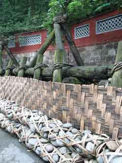
Fig. 4 Reconstruction of wicker baskets and stones traditionally used to divert river flow at Dujiangyan, Sichuan province (detail) [BGD]
In December 2002 a stone water-gauge tablet erected in 1764 was recovered in the course of a 42-day dredging and maintenance project at the ancient weirs. The one-metre high tablet is covered with complex graduated markings and Arabic numerals indicating former water levels at the dam. Li Junzhu, a senior engineer in charge of dam maintenance, was quoted in People's Daily as saying that the weirs' "water levels during the Qing dynasty were lower than in modern times". However, this statement can be taken with a grain of Sichuan rock salt, in light of the hidden agenda of the engineers from the Dujiangyan Water Management Administration, as the public relations exercise represented by those 42 days later came into stark relief (see below). The People's Daily report further noted that "conservationists also found another relic nearby which might be another water-gauge tablet but as it was severely eroded this has not yet been confirmed"[6].
On 11 May 2003 China Daily reported that a 77-year old hydraulics expert, Wu Minliang, believed that he had identified two tiled houses once part of the government's water resources bureau in Dujiangyan some 270 years previously. Mr. Wu is described as having searched for 40 years for the location of these buildings. The bureaucratic institutions that were established to manage a project over more than two tumultuous millennia warrant perhaps even more admiration from us today than the original engineering feat!
DUJIANGYAN AS A TAOIST SITE
In the Han dynasty the mastery of engineering technology (fangji) was the prerogative of a revered class of individuals designated fangshi, a title for a magus esteemed in society for skills encompassing necromancy, chemistry, medicine and magic. This worshipful reverence for those who possessed technologies to transform the material world worked with the intertwined, but seemingly conflicting, processes of apotheosis and a secular imperial honours system wielded through successive enfeoffments, to ensure that Li Bing, and the more shadowy figure of his son (said by Sima Qian to be merely "fond of hunting"), were elevated over the centuries within China's government-controlled pantheon. Yet, it is little wonder that Li Bing was deified locally for his achievements that were more tangible in Chengdu than those of Great Yu, (see Fig. 2) the legendary sage-king who stemmed the floods that inundated the Central Plains in archaic times. However, Erlang, Li Bing's "second son" (recognised only from the Song dynasty onwards), would ascend to greater prominence in the national pantheon and a statue of Erlang takes pride of place beside his father in the inner sanctum of Erwang (Two Kings) Temple on Mount Qingcheng near Dujiangyan.
The Dujiangyan area centred around Guanxian [county] was also central in the transformation of Taoism in the Shu region from a set of philosophical principles shared with other Chinese philosophical and belief systems, including Confucianism, to blend with ongoing Chinese vernacular religious beliefs and become a sectarian religion. In 143 CE, almost four centuries after the completion of the Dujiangyan weirs, apocryphal histories state that a centenarian religious hermit called Zhang Ling travelled to Mount Qingcheng where he ascribed to a disciplinary path encompassing meditation and, as a result, "ascended to heaven" to heaven as an "immortal". Zhang Ling was later regarded as the founder of religious Taoism, and a number of temples and caves on the mountain celebrate Taoist principles. Mount Qingcheng became a pilgrimage destination and the rich botanical lore of the mountain was also studied by religious practitioners in search of "elixirs of immortality". However, the temple known today as Erwangmiao (The Temple of the Two Kings, i.e. Li Bing and his "son" Erlang) had been earlier the site of the Erlang Temple at Guankou, but prior to that is believed to have been a shrine to Kaiming, the pre-Qin king of Shu also renowned for his hydraulic achievements.
UNESCO LISTING OF "THREATENED" SITE
The world's oldest fully operational hydraulic engineering project was nominated by the WHC (World Heritage Committee) of UNESCO in the year 2000 for listing as a world "cultural" heritage site, wisely in conjunction with the adjacent Taoist marchmount – Mount Qingcheng and its temples - that deify the Taoist principle of harmony with nature that find its expression in the technology and engineering of the weir. The UNESCO listing drew world attention to the significance of the site, even though the selection committee was aware of a "threat" from a proposed dam when Mount Qingcheng and the Dujiangyan Irrigation System were added to the World Heritage List on the basis of their fulfilment of three required cultural criteria (see: whc.unesco.org/archive/repcom00). The committee, meeting in Cairns, Australia, in 2000, was assured by a member of the 13-person Chinese government delegation, which included Hou Xiongfei (Chairman of the Dujiangyan Municipal People's Congress and Deng Chonghui (Director of the Dujiangyan Tourism Management Committee), that "the proposal for a new dam was only a proposition at this stage and the authorities were willing to invite foreign experts to inspect the site".
Planning of the proposed new dam was, in fact, well down the track at the time of the Cairns convention and, in November 2002, details of the Zipingpu water control project, one of ten major water control projects included in the central government's drive to develop China's central and western regions, were announced – even though the project was said to have only been "launched" in late March 2001. The press release stated that the new dam upstream from Dujiangyan would "help invigorate and prolong the life span of the ancient Dujiangyan irrigation project by diverting water into the irrigation networks during the dry season", thereby extending the area of land under irrigation from the present 670,000 hectares to more than 1 million hectares. Moreover, the ancient Dujiangyan weirs are only capable of providing 28 cubic metres per second of water to populous Chengdu, but the new project would increase the water supply to 50 cubic metres per second. Slated for completion in December 2006, the 156-metre high Zipingpu dam, equivalent to a 50-storey skyscraper, would eventually have a capacity of 1.112 billion cubic metres of water. The project's four generating units were designed to have a combined output of 760,000 kilowatts. The cost of the Zipingpu dam was estimated to be RMB 6.24 billion yuan (about USD750m).
To prepare the public for the announcement, Peng Shuming (director of the Dujiangyan Administrative Bureau) called a press conference ten days earlier announcing the bureau's recent investment of 30 million yuan (USD 3.6 million) in maintaining and dredging the ancient Dujiangyan weirs. He was quoted by China Daily on 14 November 2002 as saying, "the renovation project, to be completed in 42 days, will focus on dredging silt deposited in the inner channel, and is designed to allow the ancient water conservation scheme to operate for another 2,000 years". Peng Shuming was reported as saying that during this costly operation the ancient channel would be protected from damage caused by the use of modern machinery by using traditional methods such as constructing tripods from lashed logs and using stone-filled bamboo cages to dam the flow.
Assuaged by these pre-emptive reassurances of ecological concern on the part of the Dujiangyan Administrative Bureau and with the objections of experts quashed, there was no reaction in the Chinese press at the time, although Chinese ecologists and NGOs had long been concerned about the implications for the Dujiangyan weirs of the government's long-term hydrological plans. However, the Dujiangyan Biodiversity Strategy and Action Plan had been formulated in 2001, and there were suggestions from some international delegates at the Cairns convention that the Dujiangyan World Heritage listing nomination be extended beyond a cultural listing to include this and other natural cultural heritage projects in the Dujiangyan region. A Berkeley-based NGO, the International Rivers Network (IRN) (www.irn.org/programs/zipingpu), concerned with Chinese hydro-development on the headwaters of the Mekong soon made the Zipingpu project a matter of shared concern. In in a prefatory article titled "Dam the Consequences" published in the Far Eastern Economic Review on 7 November 2002, David Murphy revealed that IRN had acquired a copy of the 200-page report on a meeting discussing the environmental impact of new dams at Dujiangyan held as early as September 2000 – before the Cairns meeting, and behind closed doors. A copy of that document was also leaked by IRN's Chinese researchers in August 2001 to the Japan Bank for International Cooperation (JBIC), who had entered into a 32.2 billion yen loan agreement with the China Ex-Im Bank and the Sichuan Ministry of Finance to fund the dam. David Murphy wrote that "the biggest concern" at the "secret" environmental impact meeting was that a secondary dam nearest to Dujiangyan risked damaging the beauty and efficacy of the ancient weirs. Critics also singled out the Zipingpu dam's proximity to a seismic fault line, its effect on biodiversity and cultural heritage, and the technical challenge of preventing silt building up behind the planned dam. Yet these critics – from the State Cultural Relics Bureau, the Ministry of Construction, the Seismology Bureau, the State Environmental Protection Administration, the Chinese Academy of Geological Science and the Chinese Academy of Environmental Sciences, were muzzled effectively by the Ministry of Water Resources and the Chinese Academies of Hydrological and Agricultural Sciences. The tension in PRC politics surrounding rival claims to the use of water resources and hydropower has been central to the discourse of power, and Li Rui has documented those tensions going back to the 1958 Lushan Plenum's debates on the proposed Three Gorges Dam. [7]
The Chinese media remained silent. Only in 2002, following the resignation of Li Peng as premier, was the monolithic State Power Corporation dismantled. More significantly, under China's new premier Hu Jintao, who had learned well the lessons created by the old guard's attempts to suppress news of the SARS outbreak, the local media was emboldened in 2003 to report that the Dujiangyan weirs were threatened by plans drafted under the auspices of the China Water Resources Management Bureau to construct a "secondary" dam in the area – the proposed 1,200 m long Yangliuhu dam, projected to rise to a height of 23m and to span the Min River at the Yuzui section of Dujiangyan. Guangzhou's Nanfang zhoumo (Southern Weekend), one of China's more outspoken newspapers, broke the story, subsequently taken up by other media, with as many as 180 mainstream newspapers, magazines, TV and radio stations eventually covering the controversy, virtually all of them critically.
On 5 August 2003, China Daily reported that local authorities, facing growing opposition, on the previous day denied reports that they had decided to go ahead with the construction of the Yangliuhu dam. The newspaper quoted a hesitant official, identified only as Li, from the Dujiangyan Management Bureau deflecting its reporter's questions by claiming that the bureau has barely commenced its feasibility studies, adding that "now, with the surge in objections and fears that the new dam might damage the ancient weir, I do not know when the feasibility studies will be completed." Critics of the proposed new dam claim that it could empty the river downstream from Yuzui. The newspaper also reported that the Ministry of Construction and the State Bureau of Cultural Relics had just "wrapped up" their special investigations, but had not yet made public their reports.
"We promised the investigation teams we shall respect the ancient weir and build the new dam, if there is to be one, strictly according to regulations," Li said. Li also denied speculation that the new Yangliuhu dam was needed to make the Zipingpu hydropower project fully operational and to reduce its huge annual deficit of 50 million yuan (US$6 million). "We have proposed the project for the good of Dujiangyan. The dam can maintain stable river flow below the Zipingpu project and thus reduce damage at Yuzui from fluctuating water levels," a contrite Mr Li was quoted as saying. The newspaper also reported that a source from the Sichuan Cultural Relics Bureau said Li's claim was "baseless" and the Bureau will continue to oppose the dam.
On 19 September 2003 Southern Weekend reported that the Sichuan provincial authorities had decided to halt the Yangliuhu project. Ms. Wang Yongcheng, a senior correspondent at China National Radio and an active opponent of the project, commented that "this is the first time in China that the general public has had a say in a decision on an important project".
News of the environmentalists' victory came only two months after the UNESCO World Heritage Committee listed the Three Parallel Rivers National Park in Yunnan as China's 29th world heritage site. The 1.7 million hectare national park encompasses stretches of the headwaters of three of the great rivers of Asia - the Yangtze (Jinsha), Mekong and Salween. In the park the three rivers flow roughly parallel through gorges that plunge up to 3,000 m and are bordered by glaciated peaks that rise to 6,000 m. The site is described as "an epicentre of Chinese biodiversity". Chinese conservationists have already targeted hydroelectric projects on the Lancang headwaters of the Mekong for their deleterious impact on the natural environment, and international NGOs are concerned about the effects these projects will have on neighbouring countries. The 29th UNESCO heritage listing automatically calls for transparency regarding the conservation and protection of listed sites.
The controversy surrounding the threat to the Dujiangyan weirs highlights the new strength of linkage between natural and cultural heritage sites, in what some see as an incipient "green movement" tolerated, if not encouraged, by the initially more confident and open administration of Hu Jintao. On 14 January 2004 China Daily announced that in 2003 China had launched a movement to combat "illegal destructive activities" at national scenic and historic sites, and a total of 1,686 infringements had been examined. The newspaper also reported that the Minister of Construction, Wang Guangtao, had said that China was taking "substantial and effective steps to protect precious scenic and historic resources". The report also noted that Sichuan province, which has four sites on the UNESCO world heritage list, has set out new policies to protect its local heritage.
CONCLUSION
By presenting a transparent feasibility plan that takes into consideration all anticipated cultural heritage issues, the planners responsible for the South-to-North Water Diversion are showing pre-emptive foresight, lacking in the planning of the Three Gorges Hydroelectric Project and the Zipingpu Dam. The construction of the three long diversion channels will also initiate a new phase in archaeological work in long neglected areas, hopefully providing new information about China's rich past. [BGD]
NOTES:[1] Zhongguo Wenhua Yichan (China Cultural Heritage), Winter 2004 issue, pp 8-74; Xu Hongtang's preface appears on p. 7.
[2] See: Shao Yong, Fengsu tongyi, Tianjin People's Publishing House edition, 1980, pp 448-9; Anne Birrell, "The Virgin Brides and the River God", Chinese Mythology: An Introduction, Johns Hopkins UP, 1993, pp 87-88.
[3] Chang Jue's Huayang-guo zhi (Annals of the Huayang Kingdom), Ren Naiqiang ed., Shanghai Ancient Books Publishing House edition, pp 132-141.
[4] See: Carmelita Hinton, "In Search of Erlang", East Asian History, Institute of Advanced Studies, The Australian National University, June 2001, esp. pp 21-27.
[5] Carmelita Hinton, ibid., pp 1-32, esp. p. 11 and fig. 3.
[6] See: english.peopledaily.com.cn/200212/11.
[7] See also: Dai Qing, "An Interview with Li Rui", Ch. 11 in Yangtze! Yangtze!, Probe International, www.threegorgesprobe.org/p/idocuments/three_gorges/Yangtze/...
|