|
|||||||||
|
EDITORIALNo. 11, September 2007CHINA AND KOREA: A SHARED HERITAGEIn this issue of China Heritage Quarterly we examine the shared cultural heritage of China and Korea, an area of often intense debate and rivalry that has been characterised by some as the 'north-east Asian history wars'. The most bitter exchanges concern the dual role that the ancient kingdom of Gaogouli/Koguryeo plays in the histories of both China and Korea. Scholars in those countries have also been in heated debate over the invention of moveable type printing, the 'ownership' of the Mid-Autumn Festival and a number of other contested areas of cultural heritage. We discuss these topics in this issue and, under New Scholarship, also present Dane Alston's examination of a diplomatic exchange between a Chinese emperor and a Korean envoy through the medium of poetry, a discourse attempting to define Koryo's geopolitical identity. Given the block-buster exhibition related to Qin Shihuang, the First Emperor of China, that opened at the British Museum in September 2007, we are also including a short review of a book published to coincide with that event (see 'Hu's First Emperor' in New Scholarship).Lips and Teeth: The Shared Cultural Heritage of China and KoreaTraditional China, Korea and Japan shared many cultural elements, but the most salient was the use of literary Chinese (wenyan wen), the widely used written language, to frame an educational and bureaucratic world based on Confucianism. The Han-Chinese people who today regard themselves as being at the centre of the East Asian world might be forgiven for thinking that their culture had been the only civilising element among these neighbours, but this faith is as delusional as that of 19th-century inhabitants of Rome would have been if they thought that everything in Germany, Belgium and Spain derived from their ancient empire. Yet if China were the Rome of East Asia, then India was its Greece. Lying at the eastern ends of the Silk Road, China, Korea and Japan all shared in Buddhist traditions that ultimately originated in India, but these traditions were constantly remade and refashioned in the course of the religion's 'transmission'. The various religious impulses and social structures that evolved into the various Buddhist traditions did, of course, also derive from the societies in which different forms of Buddhism found their home. The Silk Road and its many branches linked the Buddhist educational centres and pilgrimage sites throughout these countries. In the 21st century, the most acrimonious debates between China and Korea in the area of cultural heritage have centred not on these major areas of shared tradition, but on more arcane issues-at least for people outside China and Korea. These debates hinge more than on origins and identity and cross the tectonic plates laid down by the two 'cold wars' that still define politics and boundaries in East Asia. The first 'cold war' came in the aftermath of the expansion of the Japanese empire and the collapse of China from the 19th century onwards, culminating in the eventual defeat of Japan in 1945 by the USA and its allies. Before the wounds that scarred East Asia had time to heal, the region was embroiled in a second 'cold war' when the victory of Communism in China and its popular following in much of East Asia raised the spectre of a Soviet takeover of Japan and the rest of the region, and the Korean War ensued. The continuing division of both China and Korea remains the legacy of this second 'cold war'. For its part, Korea is still caught in the middle of these two 'cold wars', and nationalisms in the region are highly reactive in response to these historical realities frozen in time. China and South Korea have become embroiled as reactive players in what some refer to as the 'new history wars' that surround contested aspects of what are in fact a shared cultural legacy, with both parties feeling a sense of usurpation and disenfranchisement at the hands of the other. These debates have revolved around the international recognition, often under the auspices of UNESCO, of the provenance of Gaogouli/Koguryeo culture, the ownership of the Mid-Autumn Festival and its dragon-boat racing, and other national heritage issues. Yet the debates reflect less dynastic rivalries, realities and traditions than they do post-dynastic imperialist distortions emanating from outside China and Korea. An obsession with origins and identities colours much of the debate, and Chinese paranoia about the refusal to recognise the status of Manchuria (always referred to as 'the north-east') as an integral part of China is triggered less by the expression of Korean territorial claims than by Japanese involvement in those claims and in the debate itself. The Chinese are clearly uncertain about the cultural heritage that unites, and will one day unite, the two Koreas. PrintingA debate between Chinese and Korean scholars at the end of the 20th century about who invented printing was the prelude to more recent disputes about their shared 'patrimony'. Chinese scholars had long proudly ranked printing as one of China's 'four major inventions' (si da faming). In the 1950s and early 1960s, historians of science and technology had reached a consensus view that printing was invented in China. It was one that had been gradually developed through the writings of such figures as Thomas Francis Carson, whose The Invention of Printing in China and Its Spread Westward was first published in 1925,[1] and it reached its conclusion in the writings of Joseph Needham and Tsien Tsuen-hsuin on printing, which appeared in 1985.[2] Needham and Tsien did, however, acknowledge that the Chinese, Koreans, Japanese and other East Asian cultures all contributed to the development and refinement of both woodblock printing and clay moveable type printing. The Chinese identify the inventor of clay movable type printing as Bi Sheng, a scientist of the Northern Song dynasty, active during the 1040s, this information having been recorded by another Song-dynasty scholar Shen Kuo in his well known Mengxi bitan. However, as with most breakthrough inventions, this development could only have been the result of a long period of germination and experimentation. The use by the ancient Chinese of seals to denote ownership and authority, and their use of carved blocks to print repeat patterns on fabric were very early signposts along this path of development. 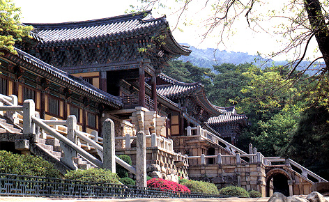 Fig.1 View of the main hall of Pulguksa temple, Kyongju, Korea. The printing had been executed by means of woodblocks. The book was dated to before 751 and pronounced to be authentic by Professors Kim Sanggi and Yi Hongjik of the Cultural Assets Preservation Committee of the Ministry of Education in Seoul. Even the subsequent discovery of the world's oldest books produced using moveable metal type and dated to 1234 went largely unacknowledged in China, where scholars believed the dating of the finds to be erroneous. The listing in 1995 by UNESCO of Pulguksa Temple, where the oldest printed volume was found, as a World Heritage Site not only focused attention on Korea's early development of woodblock printing, but also directly on that country's discovery of moveable metal type printing. Only in the late 1990s, after UNESCO acknowledged Korea's contribution to the invention of printing, were many articles published by Chinese scholars, such as Pan Jixing, refuting the claims by Korean scholars to have discovered the oldest book printed using woodblocks, and Chinese scholars were also sceptical that Korea had invented moveable metal type. However, since then, a number of French and German scholars, such as Eva Hanebutt-Benz, Wolfgang von Stromar and Henri-Jean Martin, have argued that the invention of moveable metal type by Johann Gutenberg could not have occurred in isolation, but well might have been influenced by knowledge emanating along the Silk Road from Yuan dynasty (1279-1368) China and beyond, and so Chinese historians of printing have relaxed their attacks on Korean claims but are not yet prepared to acknowledge that printing might not be a Chinese invention. A stand-off now exists between the conflicting claims of Gutenberg and his two East Asian rivals, highlighting the fact that most inventions are cultural products that do not derive from a lone inventor or even a single culture. Gaogouli ArchaeologyThe next wave of disagreement regarding the patrimony of cultural heritage centred on the ancient kingdom called Gaogouli in Chinese and Koguryo in Korean (and also transliterated as Koguryeo or Goguryeo, referred to hereafter as GK). Chinese archaeologists and historians became involved in this debate largely as innocents. Throughout the 1980s and 1990s Chinese archaeology had been gathering momentum, with a string of spectacular discoveries to its credit that challenged longstanding views regarding the origins of Chinese civilisation. Archaeology in China's peripheral areas-whether Xinjiang, Yunnan, Inner Mongolia or the north-east-had been neglected prior to the 1980s, but after the late 1970s the traditional unified archaeological picture of neolithic China originating in the Yellow River Valley was facing increasing challenges as new evidence from outlying archaeological cultures emerged. Archaeology in China's north-eastern provinces had been particularly well developed for a long time, and its beginnings can be traced back to the Japanese occupation of Manchuria. Moreover, Changchun houses one of China's most prestigious archaeology teaching universities and institutes. A series of dramatic finds at Hongshan culture neolithic sites in Liaoning and beyond made it clear that some of the earliest visual motifs in Chinese civilisation, such as the dragon and boar, may well have their origins among the stone-building cultures of the north-east and not on the Central Plains. 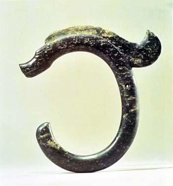 Fig.2 Hongshan culture jade representation of a dragon unearthed at the Sanxingtala site in Ongniut Banner, Inner Mongolia, in 1971. Rich finds from the various archaeological cultures of China's north-eastern provinces, such as the well-known Hongshan and Xiajiadian cultures, were found stretching from Chifeng and Chengde in the west to the border of the DPRK in the east. The neolithic and later cultures of this vast sweep of territory were characterised by their use of stone as a building material, unlike the loess and tamped earth architecture that characterised other archaeological cultures of China's north, and the castles and fortresses of GK culture evolved from this line of cultural succession. An article published in 1997 by Wang Mianhou from the Liaoning Museum is typical of the many Chinese publications on GK that appeared in the 1980s and 1990s for its examination of the history of the walled towns and cities of the kingdom of GK.[3] In that article and his subsequent monograph,[4] Wang Mianhou summarizes the Chinese archaeological approach to the polity of the Gaogouli (Koguryo) people and makes it abundantly clear that Chinese archaeologists in the 1990s were not operating according to any grand plan or hidden agenda. Many of the walled towns of GK which he describes in this article would within a decade of his writing be inscribed as World Heritage Sites. 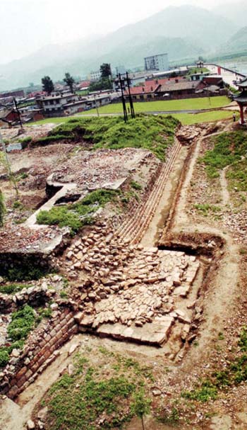 Fig.3 General view of the corner of the walls at the Guonei city site in Ji'an city, Jilin province. Guonei is an example of a GK fortress city built on the plains. It should, however, be pointed out that in the People's Republic of China (PRC) Chinese archaeologists, not surprisingly, regard everything within the boundaries of the People's Republic as an appropriate realm of study, but Wang Mianhou ostensibly makes no attempts to deny GK culture its uniqueness. Like most Chinese archaeologists, Wang accepts that the GK kingdom was eventually spread on both sides of the Yalu River (Amnok-kang) that today forms the boundary between China and North Korea, and that in the course of its seven centuries, the political centre of GK moved from well within what is today the territory of the PRC to the Yalu River valley and eventually to the area of Pyongyang in North Korea. The kingdom was finally overthrown by an alliance of the Chinese Tang dynasty and the Kingdom of Silla in the mid-7th century. South Korean critics of Chinese historians of GK later charged that they were appropriating the history of GK to make it part of Chinese history, but the fact is that Gaogouli is a part of Chinese history as defined by the borders of the PRC. Wang's article is important in hindsight because it was written before the vitriolic debate around the identity GK pitted Chinese and South Korean scholars against each other. He writes that the GK people were descended in the main from the Sui Mo people of the Dong Yi (Eastern Yi) ethnic group, one of China's ancestral tribes (although essentially 'foreigners'). He writes how the early stone walled towns of GK, which were generally constructed on mountains, hills or plateaux, drew architectural inspiration from the stone working traditions of various neolithic and bronze age peoples of China's north-east, while the political organisation of these towns or cities and their integration as administrative units within the GK polity, which resembled a loose tribal confederacy, were shaped initially by a unique nomadic 'city state' tradition that was later modified by contact with the 'feudal' administrative system of the Han dynasty. The GK 'town and city system' was based neither on independent political units like the city states of western Asia or the Mediterranean, nor on cities integrated with a central administration (fengyi) as in the Chinese state based on the patriarchal clan system. Wang Mianhou continues that the polity of the GK system was described in ancient historical texts, such as Samguk sagi (Notes on the history of the Three Kingdoms) as comprising a state enclosing central towns or fortresses and surrounding scattered tribes or village settlements. When GK first occupied territories previously administered by the Han and Wei dynasties, the prefectures and counties of the Han administrative system were re-classified as 'cities' within the GK system. With the rise of the five tribes led by chieftains and a GK royal clan, a more hierarchical arrangement of fortified towns resulted in the emergence of new military-cum-administrative positions. The author describes the urban administrative system of the GK kingdom as 'a transformation from a city state slave society with the urban unit as the core in the period contemporary with the Han dynasty to a feudalised administrative mode in which the region, prefecture and county were of prime importance'. In the late period of the GK kingdom, the central towns and cities that were mountain strongholds thus gave way to an urban system resembling that which dominated the Central Plains. The excavation of the Wunvshan (Five Virgins Mountain) city site in Huanren county, Liaoning province, in 1996 revealed bronze age material, indicating that such mountain cities pre-dated the beginning of the GK polity, i.e., the period prior to when Zhu Meng (Korean: Jumong), the ancestral leader of GK, led his people southwards into the land of the Mo people. 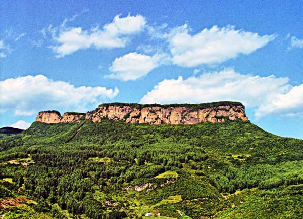 Fig.4 View of Wunvshan Mountain on the summit of which Wunvshan GK city is located. Situated in Huanren county, Liaoning province. In other words, before the establishment of the GK capital in the Hunjiang River Valley, the original inhabitants of the area had established a walled mountain stronghold of the GK type of fortified town. This would suggest that the unified culture represented by the tradition of stone walled cities and stone tombs in the Hunjiang River Valley and on both sides of the Yalu River began with the early Mo people before the entry of the people known in the historical record as the tribe of Zhu Meng who established GK. Wang is thus as interested in Chinese origins as he is in Korean origins, and elucidates his observations on the evolution of towns walled with stone in ancient times in defiance of where modern boundaries run. Yet in his explanations affirming GK's uniqueness, Wang commits the gravest sin in the eyes of Korean patriots, because he is denying GK its exclusivity as a culture-as one of Three Kingdoms that form the origins of the Korean nation. Wang argues that the GK tradition perpetuated earlier Dong Hu, Sui Mo and Mo traditions of constructing stone walls and stone tombs. These traditions which are associated with the names of non-Han ethnic groups referred to in ancient Chinese history texts are the same traditions associated today with archaeological cultures named by Chinese archaeologists for their first find sites. After the establishment of the GK state in the Hunjiang River Valley, a form of walled town construction combining architectural features of the stone walled mountain fortress and the plains fortress emerged, and the stone walls began to be constructed with a stone facing which enclosed tamped earth walls, incorporating a tradition of building adopted from Han culture. Any comprehensive study of the origins of the walled mountain towns of GK in eastern Liaoning must therefore commence with a consideration of aspects of the earlier cultural and architectural traditions of the northern peoples embodied in the Lower Layer Xiajiadian culture of western Liaoning: the choice of city site, adaptation of the city to topography, and the use of cliffs and riverine escarpments as defensive features. He delineates three periods in the evolution of the GK city (early, mid and late) and discusses typical sites of each period. Early Gaogouli periodThe earliest GK walled town known to date is the Wunvshan city site mentioned earlier, where King Dongmyeong (37-19 BCE, also known as Zhu Meng/Jumong) established his capital in the Hunjiang River Valley. This site was archaeologically surveyed in the 1950s, and since the 1980s has been excavated three times. The town was built to conform to the topography of the central levels of Wunvshan Mountain 500 metres above the valley below. The town is rectangular in plan and measures 1,000 metres from north to south and 300 metres from east to west. The walls were made entirely from stone. The location of two of the gates in the city wall can still be seen today, and the eastern and southern walls are still reasonably well preserved. In the 1950s a group of early GK graves was discovered at a site only five kilometres from the town. 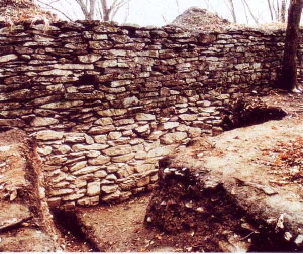 Fig.5 A view of a section of the excavated inner eastern ramparts of the Wunvshan GK city site. 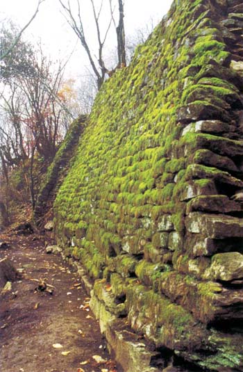 Fig.6 Well preserved section of the outer eastern ramparts of the Wunvshan GK city site. The wall is as high as 6 metres in places. Mid Gaogouli periodThis period, from the year 3 CE until 427 CE, is characterised by two city sites-Guonei and Wandu. The period ended when King Changshou (Korean: Jangsu) moved the capital to Pyongyang on the Taedong River in what is today the DPRK. Most archaeologists accept that the old earthen wall site in today's Ji'an city in China's Jilin province is the location of the GK capital Guonei, described in Samguk sagi as located on the plains below Wandu Mountain. A north-south road connected Guonei with the earlier GK centres, which were approximately 100 kilometres away. This strategic retreat to the north indicated that GK power was not yet consolidated. The outer walls of Guonei were constructed from square and rectangular blocks of stone enclosing a rammed earth and shale-like fill. The eastern wall is half a kilometre in length, but the total circumference of the city walls totals more than two and a half kilometres. The walls of Guonei are unusual among those of GK walled towns in that they feature a total of 14 ramps on the outer side. The walls have tightly fitted hewn blocks and are concave in line and retracted (corbelled) at the base, as well as having irregular masonry. There were six gates in the walls. 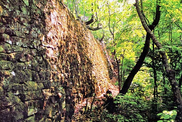 Fig.7 View of the outer walls of the Wandu (Hwando) GK city site located 2.5 kilometres north of Ji'an city, Jilin province. The walls are 5 metres high in places. 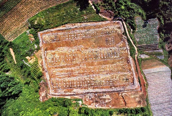 Fig.8 Aerial view of the foundations of the palace at the Wandu (Hwando) GK city site, near Ji'an city, Jilin province. Wandu, a walled stronghold town on Wandu Mountain, was contemporaneous with Guonei. There has been a long-standing controversy surrounding the location of Wandu: one school of thought favours Ji'an and another the Guanmaqiang site located some 50 kilometres to the northwest of Ji'an. Most scholars favour the Ji'an site and it is this site that would be eventually listed by UNESCO as part of the World Heritage Site. The Ji'an site was a mountain stronghold constructed on a high hill 2.5 kilometres north of Ji'an city. This walled town was built to make best defensive use of the topography of the site. For example, a steep rock face formed the south-eastern corner of the ramparts. The walls featured five city gates. Inside the city walls were the remains of a cemetery, a reservoir (popularly known as the Lily Pond), palace foundations and the ruins of a lookout terrace or reviewing stand. The palace foundations covered an area of 5,700 square metres, and measured 92 metres in length from north to south and 62 metres from east to west. Late Gaogouli periodThe later Gaogouli period begins with the move of the capital in 427 to Pyongyang, which became the centre of a group of urban complexes on the lower reaches of the Taedong river known as 'the three cities and one palace'. The Anak (Chinese: Anhe) palace is a well-known GK site near Pyongyang and it has been excavated on more than ten occasions by Korean archaeologists, but the best-known city site is the Pyongyang city site which has a circumference of 23 kilometres and covers an area of 1.85 million square metres. It is located on the opposite bank of the Taedong River from the Lelang commandery site and its tumulus tombs were discovered in the early part of the 20th century. The city adjoins mountains on its northern perimeter, and on its three other sides it is surrounded by a river. Although stone was the major medium of construction, tamped earth construction was also used. The city site consists of four precincts-an inner, central, northern and outer city; the outer city housed the ordinary citizens, the central city the officials, the inner city the palace, and the northern city the defensive garrison. However, remains of only four of the original gates have been discovered by archaeologists. A number of observation posts were been discovered in the inner and outer cities. According to Wang Mianhou, the three cities and one capital in Pyongyang present the clearest evidence of Han dynasty cultural influence on GK institutions. The palace was arranged like a Chinese palace, he claims, and conformed to the institutions outlined in the Chinese text Tong dian. This type of statement is most likely to incense Korean patriots, but within the context of GK history and research this is regarded as evidence of increasing self-assertion on the part of GK. Other Chinese archaeologists working in the 1990s and focusing on the evolution of GK tomb structures tended to also adopt the view that the GK people were an independent people, that their origins lay in the region of what is today China and the northern part of the Korean Peninsula, and that they also exerted influence on cultural developments in China. In 1995, Fang Qidong of the Jilin Cultural Relics and Archaeology Institute presented a paper at the Seventh East Asian Ancient History and Archaeology Conference in Osaka on problems in research on GK tombs at which he stated that, 'I am confident that only through assertive cooperation between scholars from China, North Korea, Japan and South Korea can our knowledge of ancient GK tombs deepen'. The Northeast China ProjectThe DPRK joined the UNESCO World Heritage Convention in 1999, and in May 2000 first pressed for the listing of 63 major GK heritage sites, and in 2001 applied to register a group of Koguryeo sites on the World Heritage list. Nomination requires a lengthy preparatory period and UNESCO will only list those sites where efforts to preserve them have been implemented, and these require inspection by an independent committee of specialists. The DPRK bid was supported by Japan and South Korea, but opposed by China. The problems of the DPRK's bid for registration were discussed at the Twenty-seventh World Heritage Convention general assembly sessions in 2003, but the bid was rejected. The Chinese felt that the status of GK within China would be denied, if only GK sites in the DPRK were listed as World Heritage sites, and the Chinese state parties to the UNESCO felt vulnerable in the wake of South Korea's successful listing of its 'printing' heritage. To better coordinate its own scholarship, the Chinese government in early 2002 established a five-year national project generally referred to in English as the 'Northeast Asia Project'. Although the project is demonised outside China, it did little more than coordinate and fund much of the publication of research already conducted by Ma Dazheng, who became head of the project, and many other scholars over the previous decade. In a paper titled 'China's Northeast Asia Project (Tongbuk kongjong) and the Reality of Koguryo', Pankaj Mohan of the University of Sydney well sums up the significance of the undertaking: It seems apparent that the project owes its genesis primarily to the pressure of contemporary political realities of China. The Chinese attempt to nationalise the history of Koguryo and other states that rose and fell within the contemporary Chinese border is meant to authenticate the political agenda of the contemporary Chinese leadership. In other words, indigenisation of Koguryo as a powerful 'ethno-symbolism' may perhaps be interpreted as a device to meet the threat of irredentist nationalism that may either originate in the region or spread from across the border.[5] China's concerns were defensive and must be seen in light of the continuing cold wars that imbue politics in northeast Asia. Chinese scholars were alarmed that the Internet was awash with South Korean bloggers accusing China of appropriating its history and depicting GK as a tributary state and ethnic minority of China. Some bloggers claimed that Manchuria was Korean territory. The Northeast Asia Project was triggered by a perceived threat to the existence of China's present borders within which Chinese archaeologists assumed their right to work. The debate aroused genuine fears and unfounded paranoia. Fortunately, the 'battle' for GK was effectively defused in the short term by the decision of the Twenty-eighth Session of the World Heritage Committee of UNESCO, meeting in Suzhou in 2004, to inscribe the capital cities and tombs of the ancient Gaogouli kingdom found in China and the complex of Koguryeo tombs around Pyongyang together. UNESCO also urged the Chinese and Koreans to cooperate in the massive task of preserving the impressive heritage of GK culture. However, at the Suzhou meeting China was forced to acquiesce in the knowledge that South Korea was successful in nominating a variant of the Mid-Autumn Festival as an Intangible Heritage property. Changbai MountainKorean-Chinese rivalry over heritage issues continues on the Internet to the present day, although it is often restrained at the scholarly level. China was given with an unpleasant reminder of how heritage issues could play out in the aftermath of Korean reunification, and so became determined to secure its northern border along the Yalu River. Changbai Mountain, called Mount Paekdu in Korean, straddles the border between China and the DPRK. 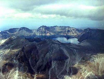 Fig.9 View of Tianchi (Korean: Chonji Lake) on the summit of Changbai Mountain (Mount Paekdu) on the border of China and the DPRK. In 2006, it was reported that China nominated Changbai Mountain for a UNESCO Natural World Heritage Site listing and wants to develop this area as a major tourist destination. The mountain is in the area inhabited by China's Korean ethnic minority, numbering more than 2.2 million and concentrated in the Yanbian Korean Autonomous Prefecture. Although the Chinese promote Changbai Mountain as a natural heritage site, the mountain range of which it is part figures in the mythology of the Manchus and is said to have been the birthplace of the earliest ancestor of the Aisin Gioro clan (the imperial clan of the Qing dynasty), although the Manchus themselves place their ancestral homelands much further north. However tenuous is the heritage grasp on Changbai Mountain of the Manchus, who have long since retired from the historical stage, Mount Paekdu is central to Korean nationalism. Some nationalist groups in South Korea claim the entire mountain, not just the Korean half, as Korean territory. A pointed reminder of this came during the 2007 Asian Winter Games in Changchun, China, when a group of Southern Korean female athletes held up signs-in Korean-during the award ceremony on 31 January proclaiming the whole of Mount Paekdu to be Korean territory. The Koreans, with more conviction than the Manchus, claim Mount Paekdu as their ancestral home. The mythical founder of Korea, Tan'gun is said to have been born here, linking the site to the country's founding myths. The Korean Peninsula is also sometimes described in Korea as stretching 'from Halla to Paekdu', Halla being a mountain located on Cheju island off the southernmost tip of Korea. The mountain is also invoked in the South Korean national anthem Aegukka (The Song of the Love of Country): 'Until the East Sea's waves run dry, and Mount Paekdu is worn away, God will watch over our land forever! Our country forever!' In the DPRK, where at least half of Mount Paekdu is actually located, the mountain has greater significance as the birthplace and revolutionary base area of Kim Il Sung, who is sometimes described as 'the son of Mount Paekdu'. His son, Kim Jong Il, is described as being 'imbued with the spirit of Paekdu'. For these reasons, the mountain has become a revolutionary pilgrimage site in the DPRK, and South Korean investors, including the Hyundai Corporation, are developing Paekdu tourism, although reportedly at a great loss. UNESCO has not yet listed Changbai Mountain as a Chinese World Heritage Site, but if it were to be listed UNESCO would almost certainly ensure that heritage-based aspirations to the tourism dollar flow to both countries.The Two Cold WarsUNESCO has found it monumentally difficult to shift heritage issues away from its states-based constituency to broader, regional concerns, but the joint listing of Chinese and DPRK Gaogouli-Koguryo sites signals that the UNESCO concept of 'human cultural heritage' might provide a model for future East Asian heritage listings. The passage to today's more measured views emanating from official circles and scholars in China and South Korea has not been smooth, but the messages of the bloggers in the Sino-Korean history wars are starting to sound contrived from the perspective of 2007. Notes:[1] Thomas Francis Carson, The Invention of Printing in China and Its Spread Westward, which was first published in 1925 and reprinted by Columbia University Press in 1995. [2] Joseph Needham and Tsien Tsuen-hsuin ed., Science and Civilisation in China, v. 5, pt.1: Paper and Printing, Cambridge, UK: Cambridge University Press, 1985. [3] Wang Mianhou, 'The system of walled towns and the capitals of Gaogouli (Koguryo)' (Gaogouli de chengyi zhidu yu ducheng), Liaohai wenwu xuekan, 1997:2, pp 89-103, 114. [4] Wang Mianhou, Gaogouli gucheng yanjiu (Research on ancient cities of Gaogouli), Beijing: Wenwu Chubanshe, 2002. [5] Pakaj Mohan, 'China's Northeast Asia Project (Tongbuk kongjong) and the Reality of Koguryo', in Changzoo Song and Inshil Choe Yoon, eds, Intellectual Engagements with Korea: Diversity in Korean Studies in Australasia (Proceedings of the Fourth KSAA Biennial Conference 14-15 July 2005), Auckland: The University of Auckland, 2005, p.82. |